Rivers State Legislators visit the Bodo Remediation Site
May 5, 2021
Kidnapping for ransom in Edo State – May 02-08, 2021
May 7, 2021
The Bodo Remediation Project has started the planting of mangrove seedlings. In total, between 1.5 to 2 million seedlings are likely to be required to cover the area affected by oil spills in the Project work area. In addition to planting, a 5-year monitoring program will evaluate their growth and survivability.
The elevation in the intertidal zone at which mangrove seedlings are planted influences both of these factors. Seedlings must receive a daily influx of marine water, but those placed too high on the shoreline, or too low in channels, basins or tidal flats, may show inhibited growth or, in worst case, cause the plant to die.
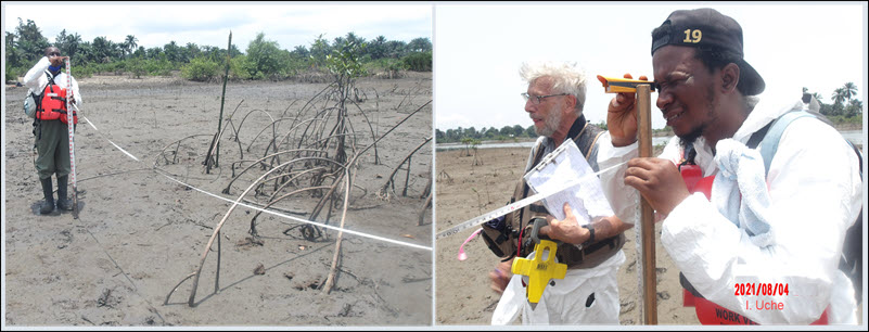
As a first look at this question, four elevation transects were measured in recently planted areas which will serve as a baseline from which to measure seedling growth and survivability at different elevations. The method of elevation profiling is well established using a handheld site level to measure vertical change and a tape to measure horizontal distance. Once the profile is established, specific ranges of elevation will be selected to monitor plant growth characteristics and survival.
Uche Izuchukwu from the BMI led the mangrove elevation profiling team with the participation of the Project Director and Deputy, Drs. Erich Gundlach and Boniface Dumpe, and others from the Project’s Shoreline Cleanup Assessment Team (SCAT) including Princess Jordan-Kagbara and Joy Paago from the Bodo Community, Peter Lenu and Bariton Lezabbey (BMI) and Vigale Giadom (SPDC).
In other parts of the globe, scientists have used the analysis of mangrove elevations to study the rise in sea level, mangrove zonation patterns and the spatial distribution of mangrove flora and fauna. Izuchukwu noted that large-scale mangrove rehabilitation projects in the Niger Delta and Nigeria are still novel and the knowledge and experience gained in studying mangrove elevation in Bodo could play a crucial role in subsequent rehabilitation programs in the Niger Delta. The use of simple and accessible equipment in collecting elevation data, and the need to pay close attention to changes in geomorphology, are part of the many lessons learnt from this activity.


